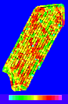
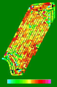
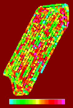
Soybean Yield |
Soil Cation Exchange Capacity |
|
Soil Doctor® System
Provides Combine Soil Mapping & Synchronized Yield Analysis |
November 26, 2001
For Immediate Release
Download this Page (Zipped PDF @ 522KB)
The pioneer Soil Doctor® System (1987), first recognized for its uniquely beneficial nitrogen management, enables the broadest range of Precision Agriculture applications. Fall 2001 introduces Crop Technology, Inc.’s latest innovation: On-the-Go soil sensing with full color mapping of soil properties --- while Harvesting.
For over 15 years, Soil Doctor systems have met most grower planting and chemical application needs through One-Trip, real-time soil sensing and concurrent VR application. One-Trip VR has recently been complemented by GIS-commanded VR application. With this latest combine innovation, Soil Doctor systems can be also be dedicated to data collection and analysis duty.
Precision Agriculture Simplified:
No-Effort, Synchronized Data Layers
Integrating soil sensing with harvesting is a unique application of the system and a great opportunity to understand field variability. For the first time ever, intensive soil data and yield data can be synchronized to an exact, common geo-referenced location, without the laborious (often fruitless) burden of "data extrapolation". Most precision agriculture data calculations comparing data collected at different times must be adjusted by an estimation formula to predict the property of interest (typically soil test data) at a point in the field where it (a soil test) was not taken. Commonly, the data is "krigged" or "weighted" to derive an approximate value, then a "shaped area" is created to further smooth-out the picture before all facts are examined.
Soybean Yield |
Soil Cation Exchange Capacity |
In this latest combine application, the Soil Doctor system synchronizes its data by using the same GPS provided for yield mapping. All data collected is exactly, automatically matched with yield monitor data. Maps, provided by Indiana cooperator Dave Shane demonstrate the detail that synchronized data sets provide. These maps show that soybean yields are inversely related to soil CEC. Soybeans yield higher in lower CEC soils and, so, can be VR seeded at the higher rates in lower CEC soils. Growers with both Soil Doctor and yield data have already determined that their yields directly correlate with field soil properties, but this new method brings sharp focus for those who have only seen yield maps, and do not yet understand the clear impact of soil variations.
Economics: -- Details Make the Difference
For years you’ve heard "precision ag pays" in many magazines and "precision ag can’t pay" from some researchers. So Who’s right? Both are. John Colburn, President of Crop Technology, Inc. says: "From the beginning, even without maps, all our customers observed that Soil Doctor technology reveals the details of the best and the worst areas in the field on-the-go and then appropriately treats them." "Now, this extraordinary tool puts both numbers and clear pictures together for easy study by the grower, consultant, researcher, custom harvester or ag-retailer." "Having the details and then acting on them is how you make precision agriculture pay." In fact, it’s the only way precision agriculture can pay off reliably, year-after-year. "Now, by offering combine data systems for rent or purchase beginning summer, 2002, we open the doors to those who have found common precision Ag methods time-consuming or frustrating."
Coarse data from limited soil sampling, such as grid sampling, often creates more heat than light. Even after-harvest cart surveys delay field operations and provide only crude estimates of soil characteristics. "Krigging" and "correlation" are then required to process that data. With always-detailed Soil Doctor data you’re done! If you wish however, you can easily supplement that body of data with a handful of confirmation soil samples pulled from exactly matched geo-referenced locations. As soon as the combine leaves the field, any ATV soil sampling can follow the exact GPS path recorded on the combine and extract as few or as many samples as desired.
And, when you have the data, you can expand data value with modern PCs. Today’s PCs have vastly improved processing capability in comparison to those available for agricultural mapping in the early 90’s. Back then, a few "zones" for GIS –based decisions may have seemed like the only pursuable GIS solution. Now, however, a grower’s economic benefits are no-longer restricted to just three (3) zones in a field. Details make the difference and a modern notebook easily commands thousands (1000s) of pre-planned, point-to-point management decisions in real-time -- each point receives a tailored treatment, rather than some arbitrary average.
Instead of waiting for years of coarse data to somehow make sense, detailed soil data explains most mysteries, enabling the end user to specify a detailed site-specific, current year fall program for both lime and potassium. Another example, instead of ripping every acre, a grower can save fuel and equipment, using topsoil depth measurements (depth to hardpan), to guide and concentrate subsoiling to only where it really needs to be done.
A grower can also get a jump on determining a variable rate soybean or corn seeding program for spring planting. And, he can decide whether he wishes to use the intensive data for truly detailed GIS-based precision application, to progress directly to real-time, performance-guaranteed nitrogen application, or to dumb the data down to just a few zone treatments.
Painless Data Collection, Mapping, and Data Analysis
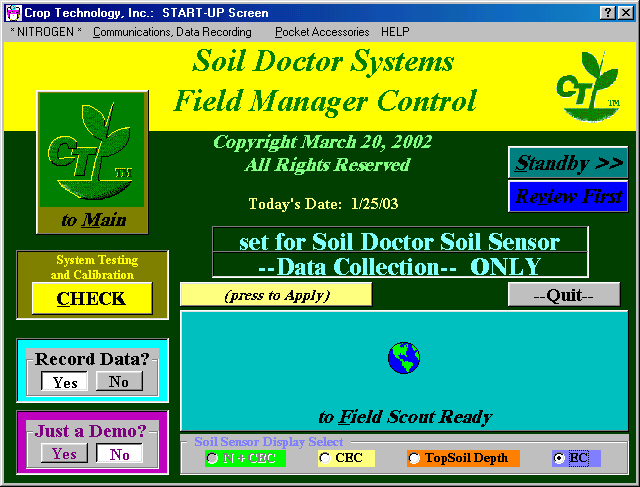
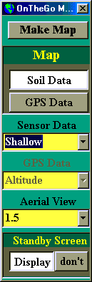
For combine service, Soil Doctor technology is operated without real-time application by simply selecting the "Soil Sensor –Data Collection" Mode at the StartUp screen. The operator then selects the Record data "YES" button and data collection with integrated mapping then becomes available.
|
|
In service, the combine operator does not need to name or specify the data files to map while harvesting. Before running in a particular field, the operator simply selects the name of the field for which he wishes to collect data. The rest is automatic. When moving to a new field, the operator selects a new Field name, and a new mapping cycle begins. The map is updated as more and more data is collected.
While in the field, the combine operator can display a variety of data maps, choosing either the average shallow measurement, the individual left or right shallow measurements, or the topsoil depth sensor readings. He can also choose to display maps of the GPS-recorded local altitude, HDOP (Horizontal Dilution of Precision), the quality of the GPS Position fix, or the number of satellites in view.
Control Panel |
"Shallow" EC |
"Deep" EC |
Soil CEC is the most important parameter for most soils and fields because it directly relates to the ability of field soils to provide water to the crop during the growing season. In many midwest circumstances topsoil is very deep, but field conditions can cause compaction, limiting productivity. A topsoil depth survey can explain why productivity can be more limited than anticipated. In regions where topsoils are relatively thin (such as Missouri or Kentucky), the variation of topsoil thickness over a field has a marked effect on productivity. Local agronomists and spot checks can best determine which factors are generally considered most influential to a grower’s production.
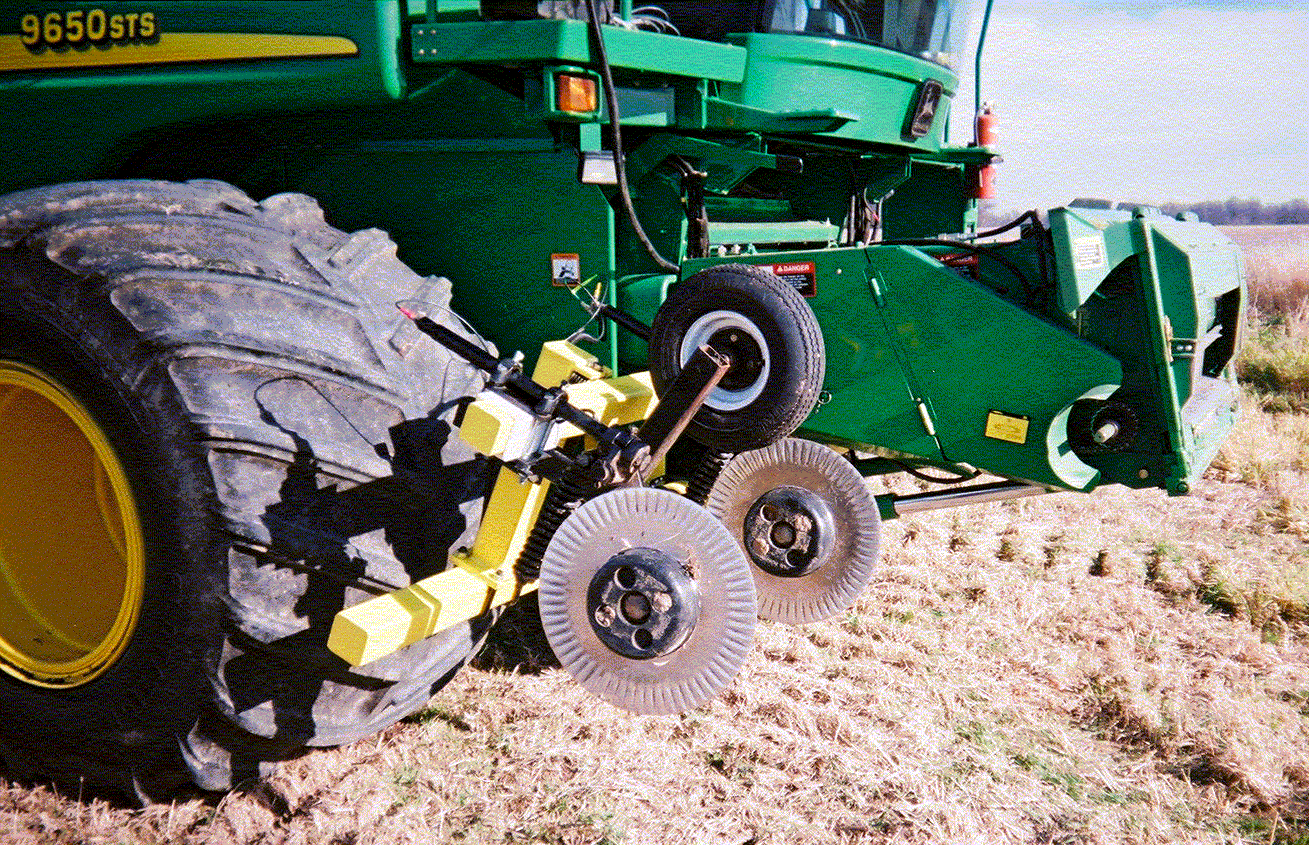
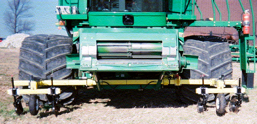
Four Electrode Array Soil Sensing Hardware
Hardware for Soil Doctor system integration with a combine consists of an electro-hydraulically operated, retractable sensor array, controllable by the combine operator. This unit may be mounted either in front of or trailing the combine’s front tires. The unit incorporates four insulated coulter electrodes forming a "four electrode array" which simultaneously measures enhanced EC at both "shallow" (1 foot) and "deep" (3 feet) depths, determining CEC and topsoil depth, as well as other measurements. Multiplexed signals are transmitted down and through the soil from one coulter blade to another in each coulter pair to determine soil properties.
The system uses the weight of the combine to provide reliable soil to coulter contact, sorely lacking in EC measuring coulter carts. Although mimicked by those carts, the 4-Electrode sensing configuration was exclusively developed and made beneficial by Crop Technology in 1989. It has been optionally available in traditional Soil Doctor applicators since 1995.
Unlike the Soil Doctor System’s electrochemical nitrate measurement technology, combine-acquired data is based strictly on Four-Electrode Array EC (electrical conductivity) measurements described in CTI’s patent specifications. These are supplemented by CTI’s patented EC enhancements (Complex Resistivity) which improve the specificity of simple EC measurements. For Midwest combine applications, Soil Doctor systems will typically assay Soil CEC and Water-holding capacity, Organic Matter, Soil Conductivity (multiple depths), and TopSoil depth.
|
|
All sensor measurements (1,250 samples per acre per sensor) are rapidly multiplexed to pairs of coulters, sequentially, typical of sidedress applications of the technology. For Topsoil depth measurements on a combine, two more coax cables connect the Soil Doctor system’s standard "Row Manager" electronics (stainless steel box at upper left of front end photo) to the TopSoil Depth potential measuring coulters.
The combine four-electrode array system is a cooperative development venture between Indiana regional dealer, Mike Pinkerton and Crop Technology, Inc. Rental hardware systems or design plans for other users throughout the United States will also be available from Mr. Pinkerton.
Rent-for-Information, Rent-to-Own Systems and Software
For the first time, Crop Technology, Inc. rents all of the needed Soil Doctor system components (Row Manager and cables) and notebook software for the one-time fee of $750 to provide the equipment to the end-user, plus a $2.50 per acre use fee. All of the per-acre fees can be applied toward the purchase of a new Soil Doctor system within the first year following use on a combine.
The customer must provide his own quality, differentially-corrected GPS and his own Windows 98 or better, PII+, 700 MHz+ notebook computer to run the Field Manager™ data management software and must also purchase a copy of Microsoft MapPoint 2002 ($249 list), Microsoft’s latest GIS software. Crop Technology has created a number of on-the-go data mapping utilities for full-color display and analysis of collected data on the combine as well as in the office and will also include its "Cartograph Shuffler™" data analysis module with the rented package. This software also correctly geo-references recorded yield data, eliminating combine grain transport lag from the data through dynamic data analysis. All collected, enhanced data can later be imported into any existing GIS program.
For Further Information, Contact: John W. Colburn, Jr., President
Crop Technology, Inc.
2868 Highway 173 North
Bandera, Texas 78003
Toll Free Phone: (866) SOIL DR N
Background Information
Soil Doctor® Soil Sensing technology is, in part, a major advancement to the exploratory, basic research conducted over the last fifty years by the United States Department of Agriculture for irrigated western states production. That body of work has been combined with CTI's expertise from the petroleum well-logging industry. After CTI introduced its technology to domestic Midwest agriculture in 1987, USDA and DOE initiated several major programs in Iowa, Missouri, Illinois, Nebraska, Texas and Idaho. The findings of this research support many scientific principles underlying CTI technology.
CTI technology is protected by patents both
issued and pending, both domestic and foreign, including U.S. patents 5,033,397;
5,673,637; 6,138,590 and 6,484,652. CTI patents cover on-the-go soil sensing
technology, incorporating electrochemistry, complex resistivity, and conductivity--serving
immediate application, post traverse GIS analyses for assay of additional soil
constituents and properties, soil fertility & chemical levels; and enable
the ONLY certified, post-survey treatments that can lawfully rely on ground-engaging,
sensed soil data.
Copyright 1997 through 2003
Crop Technology, Inc. -- All Rights Reserved